Planning for Ward 3’s future starts now
Land use Changes in Ward 3
DC is entering an important period of self-reflection on how it envisions itself changing over the next several decades. Changes to traditional growth patterns in DC do not happen by accident, they must be intentional. It all starts with the District’s Comprehensive Plan which is undergoing a mandated rewrite for how the District will change, a process the Office of Planning calls DC2050.
All land use changes in DC get their start based on two maps in the District’s Comprehensive Plan, a legislative document mandated by the Home Rule Charter that sets the foundation of the District’s zoning. Key among these is the Future Land Use Map, or FLUM (is it pronounced “floom” or “flum”? Really, it’s your choice). The FLUM, which OP is giving a bit of a glow up during this rewrite, sets out the broad levels of density for which an area can be zoned. On the residential side there are four levels: Low-scale, Moderate-scale, Medium-scale, and Large-scale. On the commercial or mixed-use side there are three levels: Neighborhood center, Urban center, and Regional center. There are three other destinations for special use areas: Institutional, Industrial, and Parks/Rec/Open Space.
In March 2026, the Office of Planning, after about a year of community engagement and surveys, released its first draft of a proposed new FLUM for DC20250. In this article, I will highlight some of the changes being proposed in Ward 3. An important point to keep in mind: THIS IS A TWO-STEP PROCESS. Changing the FLUM does not dictate or change zoning. Changing the FLUM sets the stage for what zoning could happen. Changing the FLUM is step one. Changing the zoning is step two.
Step One: Comp Plan & FLUM
Let’s dig into that a bit more. Changing the FLUM is a political process. Changes to the Comp Plan and FLUM are proposed by the Mayor, through the Office of Planning. These changes are received by the DC Council, which can do as it pleases to accept, modify, or entirely rewrite the Mayor’s proposals. The Comp Plan, including the FLUM, is a law. Your council members will vote on this. Keep that in mind between now and the primary and special election on June 16th - the winners will be voting on the Comp Plan and FLUM in the next term (OP expects to submit their plans in the Summer of 2027). What are candidates saying about it now? After June 16th is too late. Learn more from the responses given, and NOT given to both Greater Greater Washington and DC YIMBYs.
Note that Ward 3 Council Member Matthew Frumin declined to answer GGW’s questions about the new FLUM and told DC YIMBYs, “Since this plan came out very recently, I am not prepared to stake out a position on it at this point.” All other major candidates for office have laid out fairly detailed positions on the new FLUM and are supportive of OP going farther than what’s been proposed.
Step Two: Zoning
Changes to zoning are a regulatory process implemented by the Zoning Commission, a part federal, part local quasi-judicial, quasi-legislative body that sets the zoning rules and maps for DC. The five-member Zoning Commission includes three Mayoral appointees confirmed by the Council. It also includes a designee of the Architect of the Capitol and a designee of the National Park Service. Changes to zoning can be initiated by property owners, ANCs, or the Office of Planning itself.
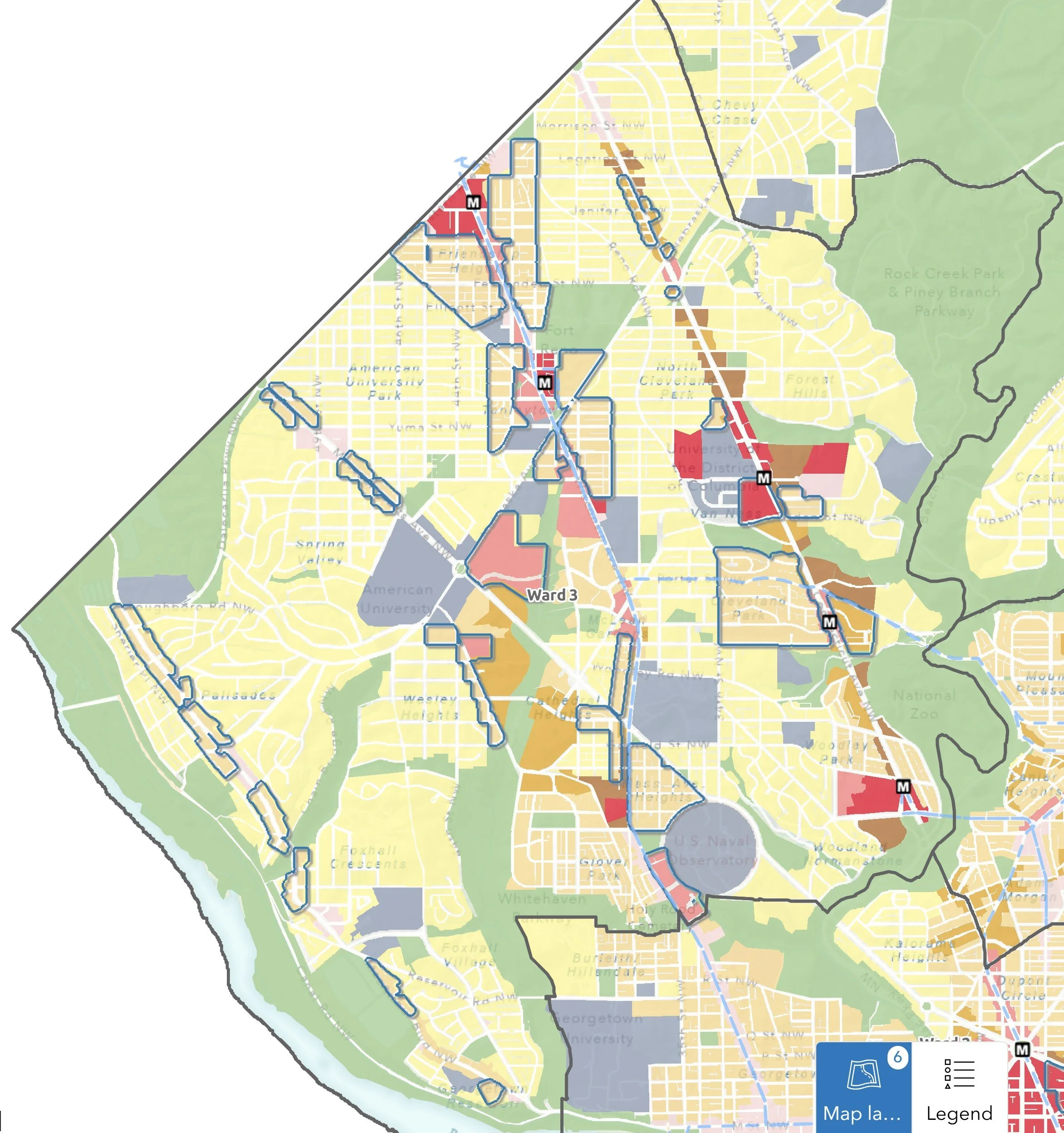
FLUM Changes in Ward 3
Perhaps the most significant changes proposed by the draft FLUM are to side-street residential neighborhoods close to transit corridors. Here OP is pitching an increase in allowable density from Low-scale to Moderate-scale. At its root, what this means is that in areas today where only single family residences are allowed, change areas could be rezoned to accommodate Moderate-scale zones, which can include a very wide range of residential zoning allowing for housing options from as small as a triplex to as large as a five-story apartment building. Again, the latter does not get decided until after the FLUM is changed.
Let me be clear - I’m a strong advocate for “gentle density,” allowing multi-family homes in areas that are currently exclusively reserved for only single family homes. It’s good land use. It would boost local vitality. It opens up more housing types at lower price points to younger families and individuals. It is more sustainable. And it is a start at bending the historic exclusionary curve that created much of Ward 3 a century ago. I’m not shying away from that advocacy, but would like for this piece to be a broad “explainer” of what’s being proposed, and hopefully helpful to anyone not familiar with the process, regardless of your views of whether you think making our neighborhoods more accessible to a broader range of neighbors is your jam.
Let’s review some areas where the upFLUM from Low to Moderate are being proposed on the side streets in Ward 3, starting with my neighborhood of Cleveland Park.
Cleveland Park (ANC 3C)
One area of Cleveland Park is being proposed for a “gentle density” increase from Low-scale to Moderate-scale. It includes the area to the West of Connecticut Avenue to 34th Street/Reno Road, between Rodman Street and the North side of Macomb Street. This area includes nearly all of ANC 3C05 and a portion of ANC 3C06.
This area currently has two residential zones: South of Ordway Street is zoned R1B which allows detached single family houses with side (8’) and rear (25’) setbacks, a 40% lot occupancy, a three-story/40 foot height limit, a minimum lot size of 5,000 square feet. The area includes non-conforming small apartment buildings and semi-detached homes. North of Ordway street is zoned R2, which allows for semi-detached homes, although have much of the same development requirements of the R1B zone. Here too exist non-conforming small multi-family along Porter and Rodman Streets. Both zones allow for only one dwelling unit, with the exception of an accessory dwelling unit, or ADU, in the form of a backyard building or basement apartment.
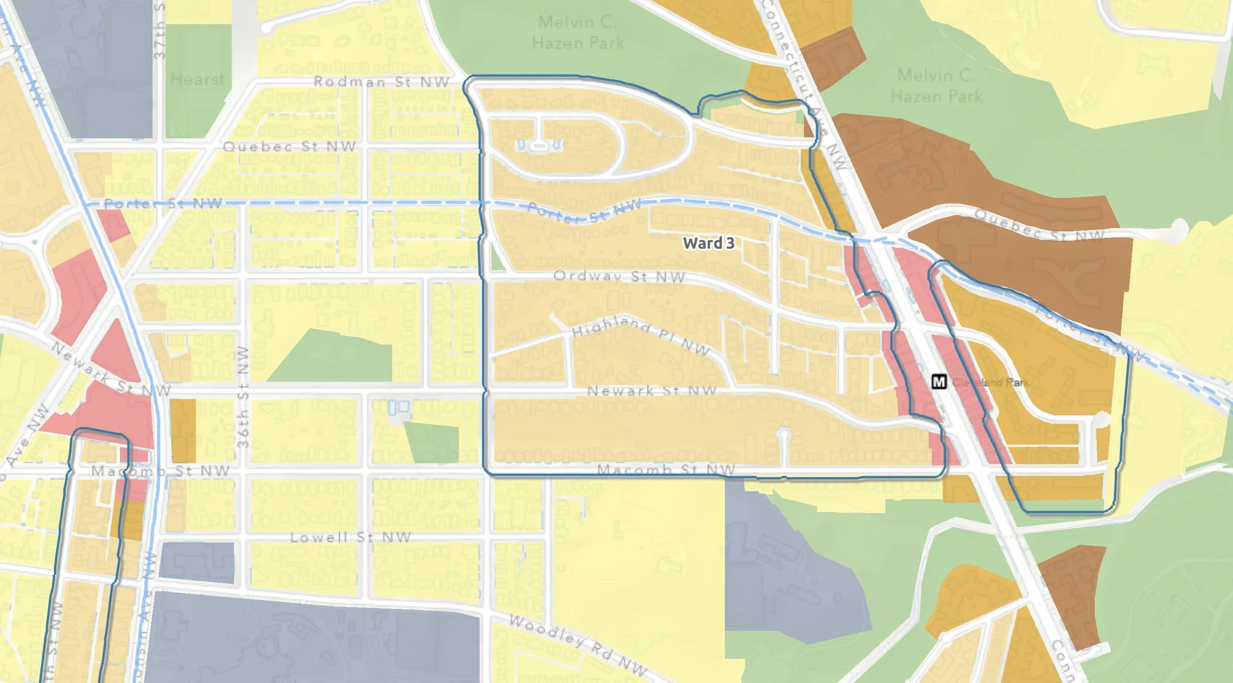
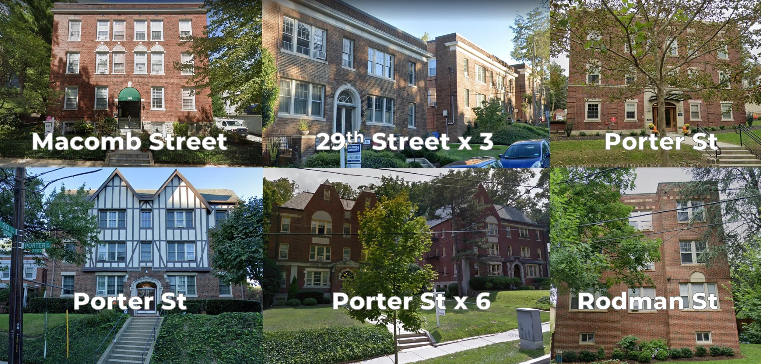
The entirety of this change area is within the Cleveland Park historic district. That means future changes in density would be restricted to the contributing buildings that exist, expanded to the degree both zoning and the Historic Preservation Review Board allows. Non-contributing buildings (those built after 1941) could be replaced with new buildings, but would still require HPRB review for compatibility. As much as one might like to see modern versions of the small multi-family buildings (see illustration below) that dot the side streets of this area, what is likely to be allowed are residential conversions of larger homes into multiple smaller homes. There are a number of examples of this type of detached home conversions in the Mount Pleasant historic district.
Allowing multi-family conversions in this part of Cleveland Park should be an easy change. By law, the physical characteristics of the neighborhood cannot dramatically change from the view of the street. Demising a 6,000 square foot home into three 2,000 square foot homes seems like a great solution for middle housing that would have price points, while not low, certainly less than the single family home they replace.
My question, why stop at 34th Street/Reno Road? Why not extend to Wisconsin Avenue? Both Wisconsin Ave and Connecticut Ave are transit corridors. Also, a personal peeve - why not include the southern side of Macomb Street (where I live!)? A lot of the decisions OP made in the recommendations do not add up.
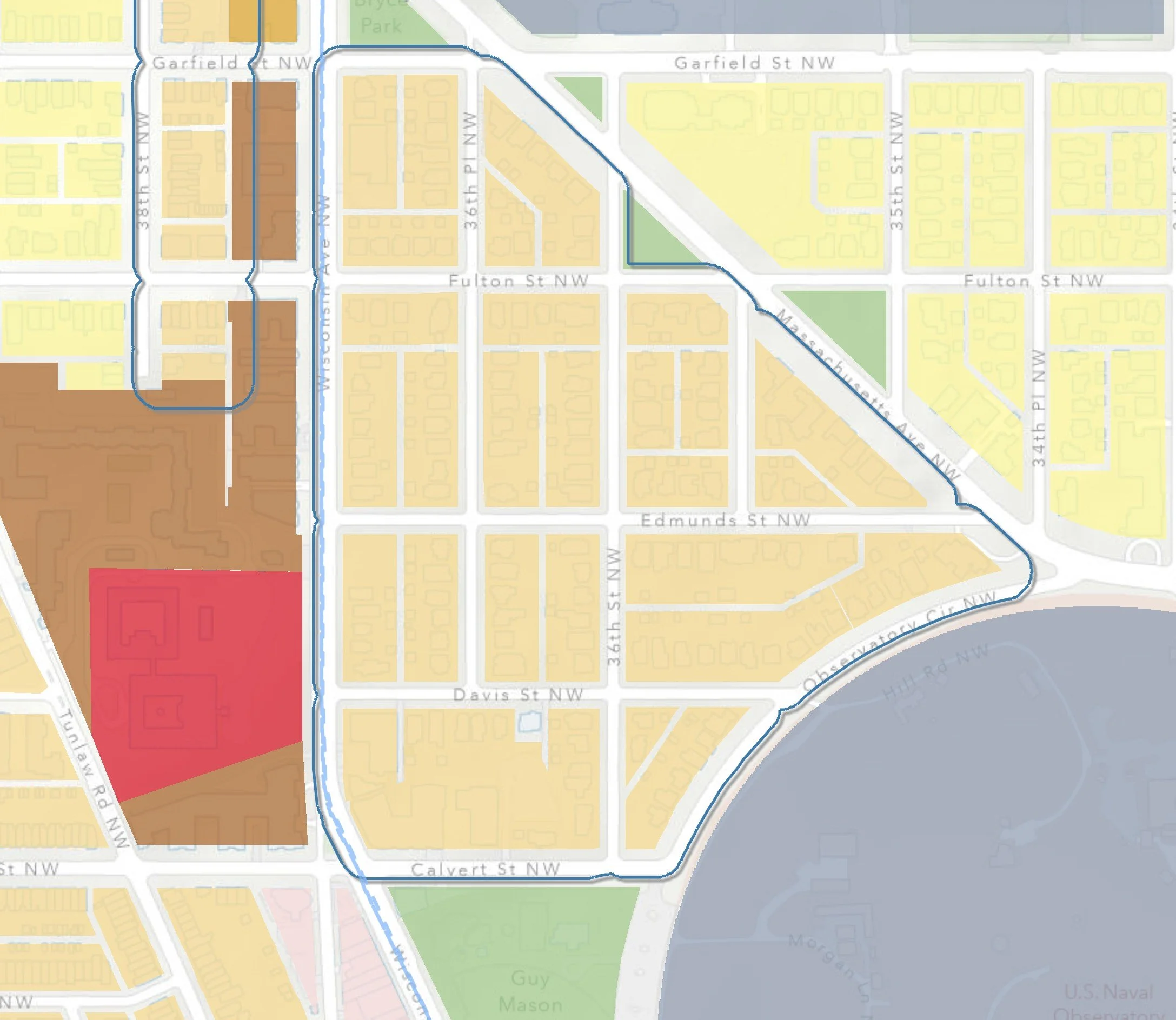
Massachusetts Avenue Heights (ANC 3C)
The area within ANC 3C08 that falls between Wisconsin Ave, Massachusetts Ave, Observatory Circle, and Calvert Street, in the Massachusetts Ave Heights neighborhood, is being proposed by OP to upFLUM from Low-scale to Moderate-scale. Wisconsin Ave is designated as part of the moveDC and WMATA Transit-priority network. This area is currently zoned R1B and is home to almost exclusively single family detached homes, with the exception of the Glover Park Hotel and the adjacent condos at Wisconsin & Calvert and the church next door.
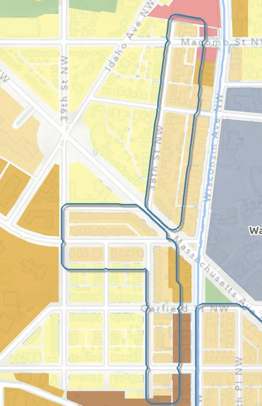
Cathedral Heights (ANC 3A & 3B)
Areas on the West side of blocks whose East side fronts Wisconsin Ave, including 38th Street just South of Fulton Street up to Cathedral Commons just above Macomb Street, and both sides of Cathedral Ave from 38th to 39th, and the South side of Klingle Place between Massachusetts Ave and 39th Street are slated for an upFLUM from Low-scale to Moderate-scale. This change area touches 3B01, 3A02, and 3A05. The areas are currently zoned R2 in most of the area south of Mass Ave, although there are some non-conforming row houses. North of Mass Ave the zoning is R1B although there are examples of non-comforming semi-detached homes.
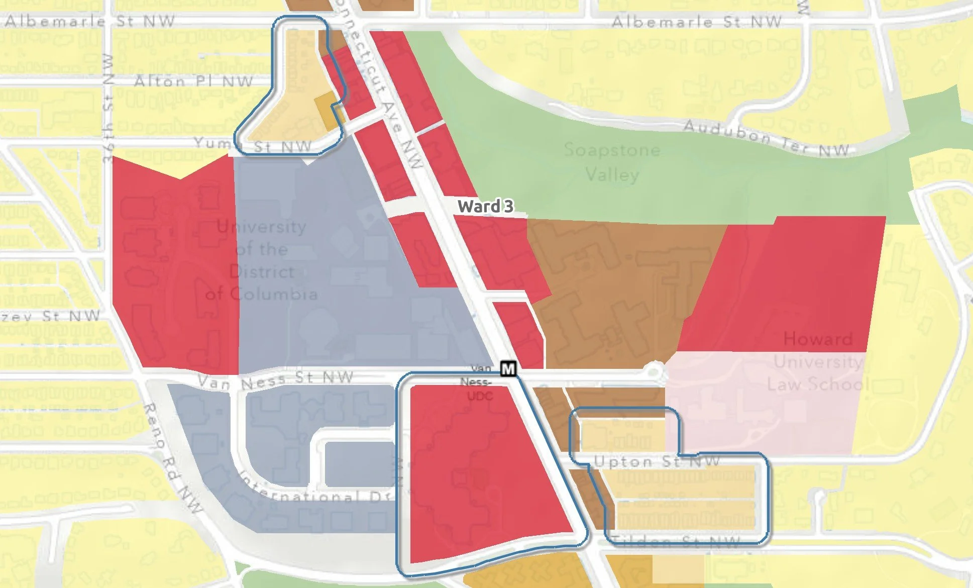
Van Ness (ANC 3F)
Two change areas are proposed in the Van Ness area to upFLUM from Low-scale to Moderate scale, one on either side of Connecticut Ave. Both are in 3F05. The first, on the East side of Connecticut and includes Upton Street and the North side of Tilden Street east of Connecticut Ave to 29th Street. The area is zoned R2 for semi-detached homes, although the area seems to have as many rowhomes as semi-detached homes. These are within two blocks of the Van Ness Metro station.
The second area, just North of UDC on the West side of Connecticut Ave, includes the portion of the block off Connecticut Ave from Albemarle, 35th, and Yuma Streets. The parking garage on Yuma behind the Days Inn is already designated as Medium-scale and would remain so. This area is currently zoned R1B although nearly all of the buildings are semi-detached homes as well as garden apartments on Yuma Street.
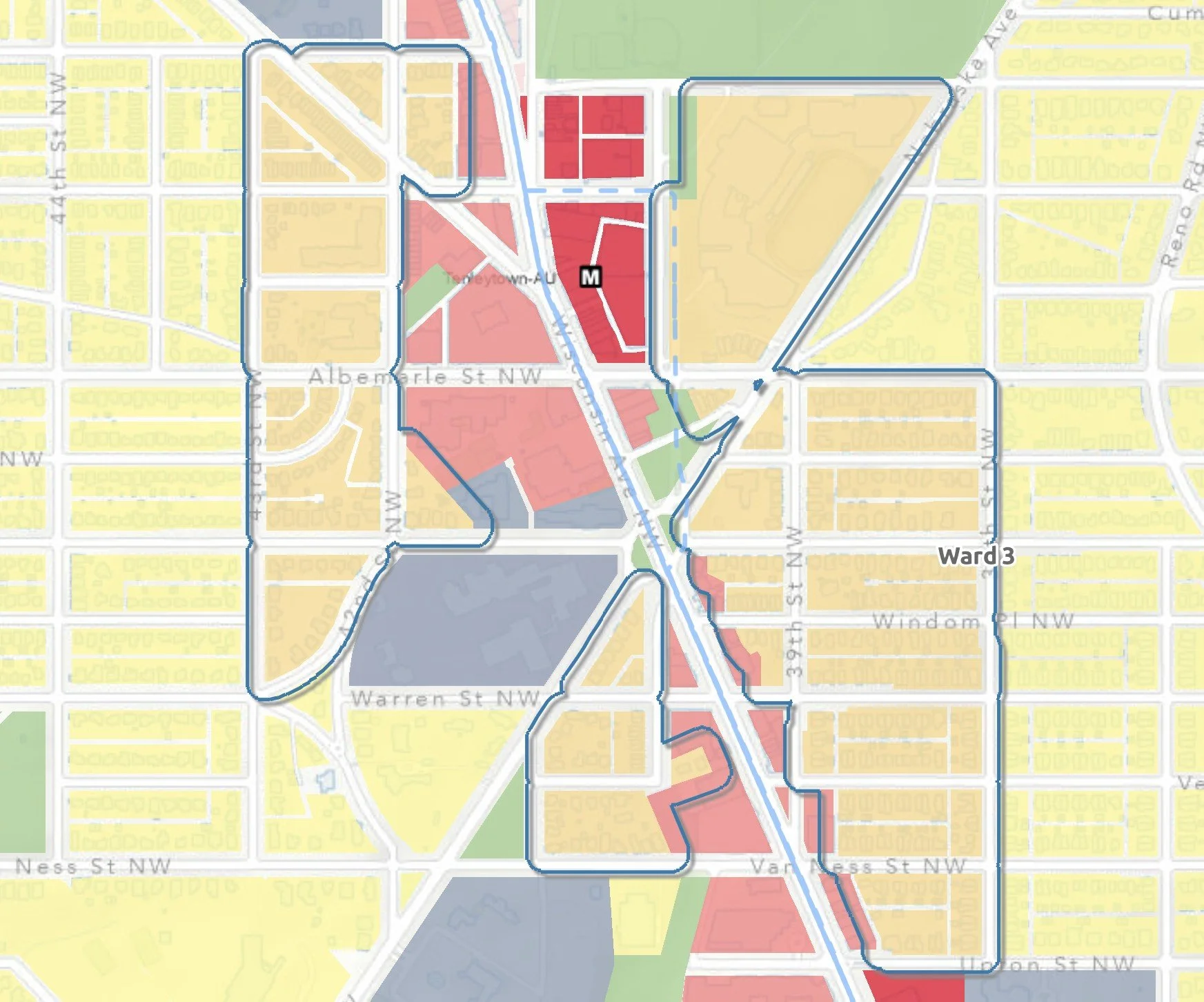
Tenleytown (ANC 3A & 3E)
Three change areas in the Tenleytown area call for an upFLUM from Low-scale to Moderate-scale. The first area, which includes parts of 3A03 and 3E05, is on the East side of Wisconsin Ave East to 38th Street between Albemarle and Upton Streets. It also includes the Western portion of the Albemarle & Nebraska intersection as well the entirety of the block encompassing Jack-Reed High School. From Upton up to Warren Street, the area is zoned R2 for semi-detached homes, which is the prevailing home type. North of Warren the zoning is R1B, although some non-conforming semi-detached homes can be found there.
The second change area is on the West side of Wisconsin Ave just South of Tenley Circle, in 3A04. The area is bounded by Nebraska Ave, 41st Street, and Van Ness Street, sitting behind the commercial row on Wisconsin that includes the area where Surfside up to the firehouse are located. The area has both R1B and R2 zoning.
The third change area, also on the West side of Wisconsin Ave, includes the residential areas West of Wisconsin Ave, the educational campuses of AU Law School and Janney elementary, and the commercial block anchored by the Cityline development, to 43rd Street, between Chesapeake and Warren Streets. This area covers both ANC 3E01 and 3E06, and is zoned R1B. This area is between one and three blocks from the Tenleytown Metro station and the Wisconsin Ave bus lines.
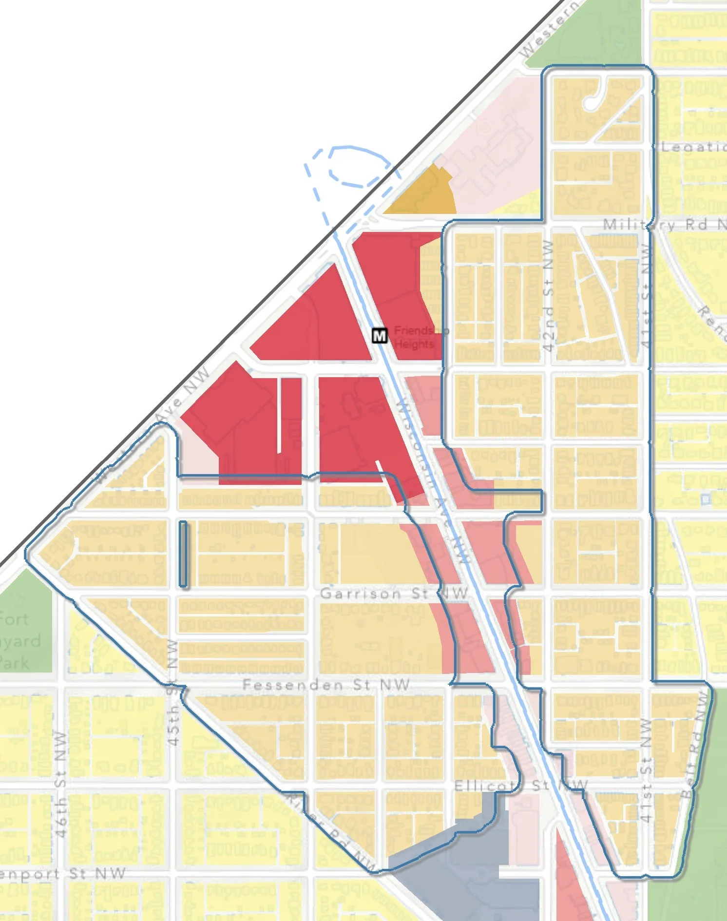
Friendship Heights (ANC 3E & 3/4G)
Two change areas in the Friendship Heights area are proposed to upFLUM from Low-scale to Moderate-scale, one on either side of Wisconsin Ave. On the East side, covering parts of 3E03, 3E04, and 3/4G06, is the residential area between Wisconsin Ave and 41st Street from Livingston down to Davenport, and the portion of Belt Road adjacent to Fort Reno Park. The area is currently zoned R2 for semi-detached homes. Some non-conforming row homes exist in the area. The area is within one to three blocks from the Wisconsin Ave bus lines and in the Northern portion of the area within three blocks of the Friendship Heights Metro station.
On the West side of Wisconsin Ave, covering parts of 3E03 and 3E04, is the residential area between Wisconsin Ave and River Road, North of the GDS campus to the Maryland line. The current zoning is a mix of R1B closer to River Road, R2 and a block of R3 (row houses) at 43rd St and Ellicott. The area is within one to four blocks to the Wisconsin Ave bus lines.
Other Parts of Ward 3 (Mostly ANC 3D)
Several other areas of Ward, largely in ANC 3D, have change areas that upFLUM from Low-scale to Moderate-scale, but these happen on bus corridors themselves, rather than the side streets. Changes can be found along Mass Ave in Spring Valley, along New Mexico Ave in Wesley Heights, and along MacArthur Boulevard in the Palisades.
What’s Missing?
Many housing advocates, including me, look at the proposed FLUM as a missed opportunity, shuffle steps into the future in some areas and inexplicably hiding under a rock in others. There is an argument to be made, which I support, that six-plexes should be legal throughout all of DC, something the major mayoral candidates including Janeese Lewis George, Kenyan McDuffie, Gary Goodweather, and Rini Sampath support, as do at-large candidates Lisa Raymond and Elissa Silverman. Notably, Ward 3 Councilmember Matthew Frumin does not.. A new Mayor will be delivering this FLUM to the new Council next year, and so changes to expand housing opportunities are likely.
Even if you take the more conservative view that legalizing apartments in areas within a ½ mile of transit corridors is the better approach, rather than a blanket district-wide approach, this map falls woefully short. Three enormous gaps to be filled:
The entire area between Wisconsin and Connecticut Avenues is within a half mile of a transit corridor and should be upFLUMed.
Residential areas within a ½ mile East of Connecticut Ave should be upFLUMed.
Residential areas within a ½ mile West of Wisconsin Ave should be upFLUMed.
Time is running out to have your questions answered by candidates who, if successful, will be acting on these issues next year. The at-large special election and the Democratic primary election is in two months, on June 16th. ANCs will play a role in this as well, and those candidates declare their candidacies in early July. Now is the time to ask questions and demand answers.